The use of drones in agriculture
Drones in agriculture – investment or an expensive necessity?
Cutting Edge technologies can seem like expensive but unnecessary toys, also in agriculture. What new things can be invented in the field developed since the cradle of civilization? Why change something that has been improved for hundreds of generations and works better than ever?
UAV in agriculture appeared relatively recently. Initially, resembling capabilities of manned flights or satellite images used before.
How can an investment into an UAV help a farmer improve his farm management instead of being only just a costly expense of “mandatory modernization”.
How do drones collect data?
Investment and modernization processes are not made just for the sake of making them. The potential of technologically dominant tools lies in the opportunities they provide, which then translate into specific effects for the farm.
The strength of new technologies lies in the data – the type, quality and speed of information provided to the farmer.
Man has been involved in agriculture for millenia. The knowledge about cultivation that has been passed from generation to generation doesn’t dynamically change. Used technologies change, but actions taken by farmers remain the same – plowing, fertilizing, sowing, spraying…
What limits farmers the most is the knowledge about what is happening with their crops. How much fertilizer is needed, which areas lack water, when and where pests have attacked.
Lack of such knowledge results in decisions based on guesses and assumptions, instead of facts, and often with long delays (or when it’s too late).
SlantRange describes methods of collecting data from fields and categorizes them in terms of two factors – accessibility of data and their accuracy.
- Human supervision – human inspections in the field dominate over other techniques in terms of accuracy due to man’s extensive knowledge, experience and precision. The biggest limitation is poor scalability – a human isn’t physically able to survey a multi-hectare area within a reasonable time, not to mention examining every single plant separately
- Agricultural sensors – can be widely distributed even on large areas, and thus, more accurately study the parameters of the field. However, they have limited use, such as soil moisture, pH or optical soil parameter testing
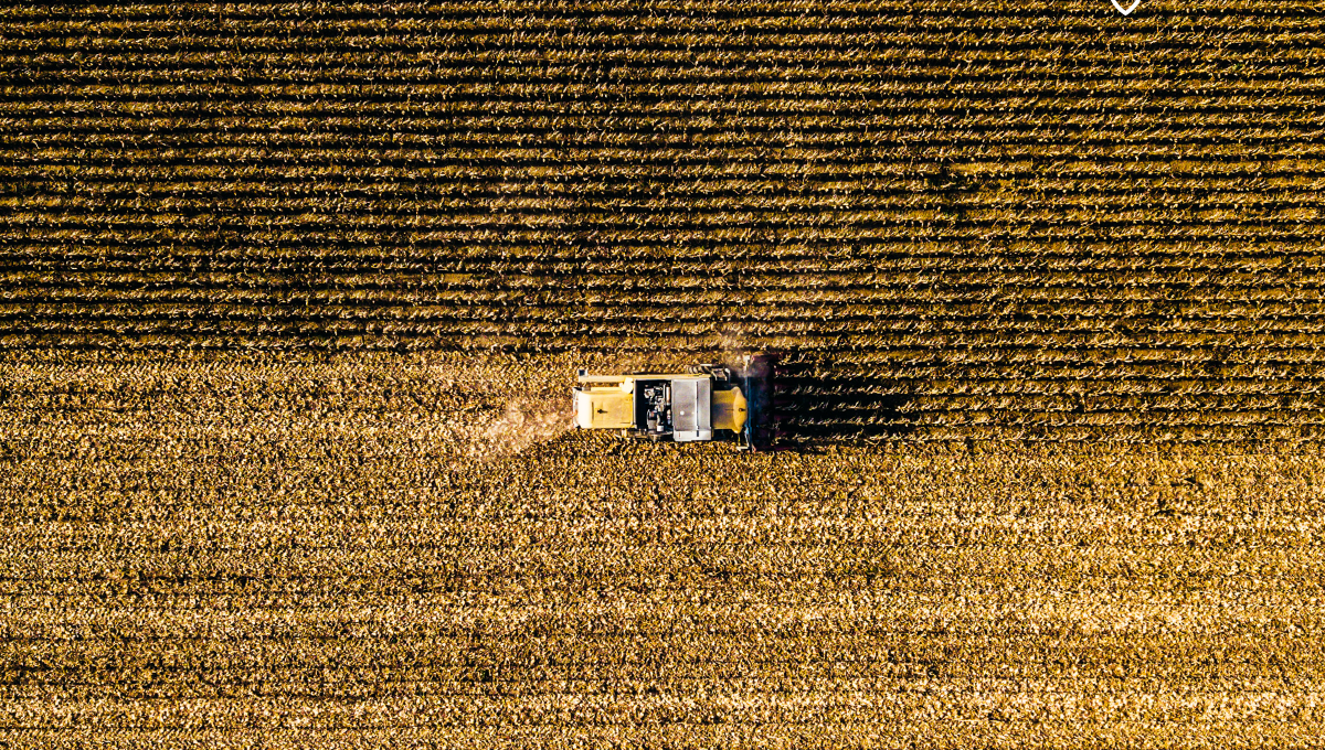
- Drones – with a whole arsenal of available cameras, sensors and with their mobility, they optimally balance between quantity and quality of collected data and the speed of data collection from large areas.
- Manned flights and satellites – due to considerably higher cost, slower data collection and worse precision, despite the wide application, rank behind the UAV technology
Precision agriculture – variable parameters
Field surveillance with the help of drones allows you to take highly accurate actions in less time than ever.
Drones equipped with a specially selected camera or a sensor set provide comprehensive information about soil humidity, distribution of fertilizers and micronutrients, diseases, pests or maturity of crops.
In the case of some types of crops it is possible to perform a detailed inspection of single plants. For example vineyards – a drone with a camera inspects the entire plantation, vine after vine. Then an accurate report is generated in the form of a map with marked maturity indices of each plant. Using information from the map, the wineyard’s owner can selectively harvest ready plants. In this way, the problem of uneven ripening and lower quality of collected fruits, which differ from one another, has been eliminated.
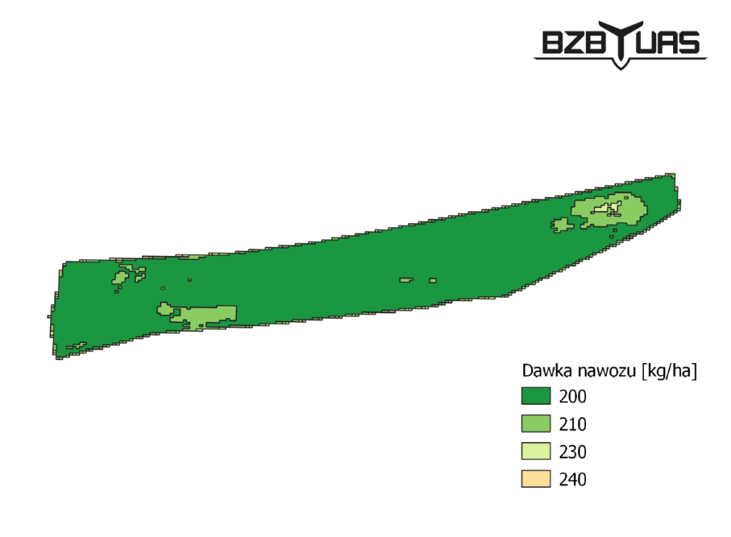
This kind of maps can be also used with other types of plants e.g. for selective application of fertilizer, research on soil melioration, adaptation of crops to proper humidity or combating diseases.
Digitization of analog farming
With detailed data and reports based on the conclusions from their analysis, a farmer is able to increase the effectiveness of his farm in two ways.
The first is to reduce fertilizer costs. By examining the state of development of plants in different parts of the field, a farmer can calculate the right amount of fertilizer that the crops need (or do not need).
Until now the farmer estimated the amount of fertilizer on the basis of limited information. That caused some of the plants to not receive the right amount of fertilizer required for their growth, while other were over-fertilized
The second source of farm optimization is the maximization of crop yield. Thanks to the precise application of fertilizers, the farmer minimizes plant losses and increases yield abundance, that means the farmer will earn more after the harvest.
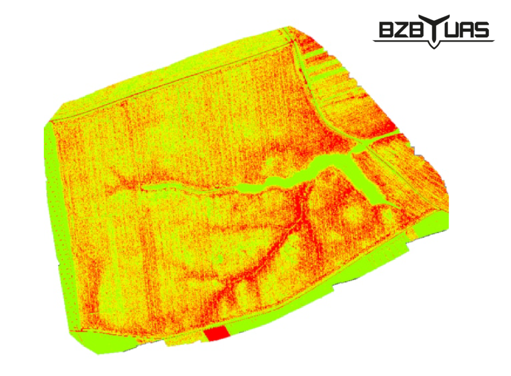
NDVI index – multispectral cameras
One of the indices provided to farmers by drone technologies is NDVI (Normalized Difference Vegetation Index) i.e. plant vegetation index. A multispectral camera examines the intensity of reflected and absorbed light in the infrared and red bands.
On its basis it is possible to detect live, green parts of plants and those plants that, for some reason, don’t develop properly.
These data are used to find the cause of abnormal development, to apply the appropriate dose of an appropriate fertilizer, plan cultivation in the following years, detect irregularities in field’s melioration. All these measures lead to cost savings and maximized yields.
Supervision of individual plants

With precise cameras and GPS modules drones are able to inspect individual plants. Such inspection provides not only information about the plants readiness for harvest but also detailed knowledge about plants development and possibility of taking a precise action.
Combination of data collected from several types of sensors can be used to detect plants with increased level of stress, uneven growth or the presence of pests.
In the example of a vineyard, some vines may produce more leaves than others. As a result, grapes from one crop will differ in the case of sun exposure and, as a result, will differ in the degree of ripeness, sweetness and taste. The ability to detect such anomalies and appropriate reaction will allow to obtain homogenous material for creation of high-quality wine.
Advantages of drones in agriculture
- Speed of data collection – after the field is scanned, the report is available up to 24 hours, and in some cases even immediately.
- Amount of data collected – thanks to the whole range of cameras and sensors, drones aren’t limited to collecting one or several basic parameters.
- Automation – man can entrust more and more activities related to cultivation to the machine, from crop monitoring to spraying and deterring wild animals.
- Remote operation – thanks to automation and artificial intelligence, most operations performed with a drone are done remotely, without having to move across the entire field.
- Precision – measurements done by a drone may even refer to a single plant.
- Quick reaction – thanks to the inspections and monitoring of the field, the farmer can react to occurring processes and damages immediately, within days or hours, not weeks
- Mobility – Unmanned Aerial Vehicles can traverse multi-hectares of land in a short period of time, taking off and landing in places where other methods would be difficult or impossible to access.
Artificial Intelligence in agriculture
Drones in agriculture are not just high-tech sensors and maps with generated indices. They are also highly specialized artificial intelligence (AI) algorithms that support or replace human activities
The increasing access to an increasing amount of data of excellent quality means that machine learning and artificial intelligence are able to enter agriculture. This has, for example, the potential to automate the time-consuming and repetitive activities performed by farmers, or to learn dependencies and processes in plant development that go beyond best experienced farmers.
In the future such digitized farms may require only minimal intervention from the farmer. Drones will automatically perform missions and scan crops and farmland, decide about the time of sowing, spraying or harvesting, and then coordinate the work of the rest of the automated agricultural machinery. All of this to maximize the profit and savings and for the convenience of farmers’ work.
Supervision of crops with drones – field inventory
Precise drone flights help not only to take specific actions but also with inventory and monitoring, e.g. in the case of forests or orchards. In large orchards with up to tens of thousands of trees of different species and age, orchardman often lack specific knowledge about their plants.
A drone with an appropriate camera can analyze the number of trees, categorize their species, assess the age and size of the crown, check their health and estimate the yield of the entire orchard.
Monitoring and damage analysis with an UAV
Thanks to regular monitoring, farmers can not only optimize plant growth on an ongoing basis, but also detect what every farmer would like to avoid – damage to crops.
In the case of both agricultural damage and damage caused by wildlife, the sooner the farmer becomes aware of it, the better he can react. In the event of drought, pests or damage caused by wild animals, an ortophotomap, made with the use of a drone, will allow you to detect the damaged area and assess its size and severity, plan corrective actions and protect plants for future.
The maps themselves can be attached to the documentation as evidence of damage and allow for precise loss estimation. In this way, the farmer can maximize his chances of getting the right amount of compensation from the hunting club or insurance company.
The future of technology and agriculture?
Taking into account the current trends, we expect (or rather we are sure) further intensive development of the digitization of agriculture.
The capabilities and applications of sensors will be further developed, and the data collected by them will be integrated into existing solutions, providing even more valuable information about the crop development. Artificial intelligence algorithms, using the collected data, will draw more and more accurate conclusions and recommendations about actions that need to be taken.
Automated equipment will help people more and more, and perform agricultural activities at lightning speed, with watchmaking precision. Complicated systems (e.g. UAS systems) will combine technologies and control devices that work simultaneously.
The human role will move over time from dealing with farm activities to supervision and monitoring of digital systems operating on the farm. A farm operating in this way will be focused on optimizing expenses, minimizing costs related to cultivation and maximizing the quantity and quality of obtained crops.

